
Mapping Public Health Overview
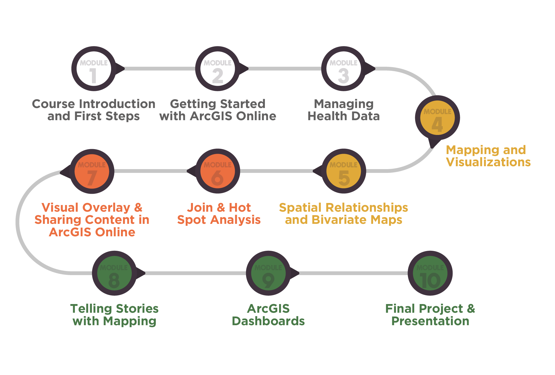
- This course is asynchronous and consists of 10 modules.
- The course is self-paced, with all materials available to participants from the start.
- Upon completion and submission of the required assignments, participants will receive a certificate.
- Participants can earn additional certificates by completing Esri Web Courses that are part of the assignments.
- Participants will also have the option to complete additional Esri Web Courses to earn further certificates.
- After completing the course, participants will receive 6 months of extended access to THRC's ArcGIS Online, allowing them to continue exploring data sources and enhancing their skills.
Course Structure
Course Outcomes
By the end of this training, you will be able to:

Develop a basic understanding of GIS fundamentals and their applications in public health.
Access and import publicly available health data for analyzing and creating map layouts
Create a Story Map and an interactive dashboard to showcase your analysis and maps
Publish and share maps, story maps, and dashboards
Course Delivery
The course is asynchronous via an online platform. Participants can contact the instructor by email, schedule office hour meetings, or request alternative times. Discussion forums provide collaboration and support.
Course & Technology Requirements
No prior GIS or data knowledge is needed. This course introduces GIS fundamentals for public health, with resources supporting learning from basic to intermediate levels using ArcGIS.
Requirements:
- Computer with internet access
- Basic computer and software familiarity
Course Certificate Requirements
This course does not require the submission of weekly assignments. To earn the final certificate, participants will need to complete the following requirements:

Submit PDF Files
Submit the PDF files of the three certificates earned by completing Esri Web Courses within the modules. The deadline for this requirement is Week 8.

Take Final Quiz
Take a final 10-question quiz at the end of the course to assess their knowledge of the theoretical content. Participants will have unlimited attempts but must answer all 10 questions correctly to fulfill this requirement for the final certificate. The deadline for this requirement is the end of Week 9.

Create a StoryMap and Dashboard
Showcase maps and other content developed through guided labs. Participants can reproduce maps from the guided labs. Alternatively, they can create different maps relevant to their professional needs. It is important to showcase the GIS and cartographic techniques learned within each module.

Prepare a Video Presentation
Prepare a 5 to 10-minute video to present their work to their classmates. The deadline for this requirement is the end of Week 10.
Discussion Posts
This course includes three discussions:
- Introductions – Participants post brief intros to network.
- Course Topic – Discuss a relevant subject.
- Project Sharing – Share StoryMaps/Dashboards for feedback and collaboration.
Participation is encouraged but not required for certification.
Post-Course Support
Participants receive 6 months of extended access to THRC’s ArcGIS Online, ArcGIS Pro, Living Atlas, and Esri apps after course completion. THRC also helps organizations explore Esri licensing options based on funding.
Esri provides special pricing for non-profit organizations:
- Nonprofits (501c3) – Special pricing available. Apply here
- Personal Use – Affordable individual licensing. Learn more